Thursday, June 30, 2011
GeoVenturing RO/CS (River Orienteering / Community Stewardship) @ http://bit.ly/khOM0i
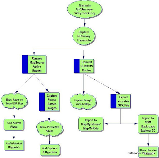
Garmin GPSurvey-Waymarking:
Capture GPSurvey Traceroute
Rename MapSource Active Routes
Show Route on Topo-USA Map
Find Nearest Places
Add Historical Waypoints
Capture Picasa Screen Images
Share PicasaWeb Album
Add Captions & Hyperlinks
Convert to RO/CS Routes:
Export sharable GPX File
Import to MapMyFitness/MapMyRide
Import to NGM Backroads Explorer 3D
Show Elevation Profiles
Capture Google Maps Collage


Saturday, September 29, 2007
2007 SFTA Symposium Eco-History (7929am)
 Selected GPSurvey waypoints visited enroute from Fort Leavenworth:
Tracepoints captured by Garmin eTrex Legend GPS Unit & uploaded via TOPO! Version 4.2.7 ...
http://maps.nationalgeographic.com/category/Outdoor%20Recreation%20Mapping%20Software/?cid=3&tid=0
TOPO! GPS Data Format Deg NAD83 ElevFeet Local-Time
WILLOWSPGS,36.90823,-104.43891,6693,09/29/2007,08:58:39, Raton, NM (505 ) 445-9397
EAGLE NEST,36.55475,-105.26362,8203,08/29/2007,20:47:13,EAGLE NEST / THELMA
NINEMILENM,36.43059,-105.29056,8334,09/29/2007,08:58:26,NINEMILE CREEKNM
9MILECRK,36.44943,-105.34017,9167,09/29/2007,08:58:27,
WHEELERPK,36.55669,-105.41695,13160,09/29/2007,08:58:39,
TSJCSTUCTR,37.17203,-104.51468,6074,09/29/2007,08:58:36,
MESAEMAYA,37.01713,-103.88273,6280,09/29/2007,08:58:23,
BRANSON-CO,37.01569,-103.87848,NA,09/29/2007,08:58:03,
OLDBENTSFT,38.04380,-103.43156,4006,09/29/2007,08:58:28,
==========
CIMARRONOK,37.03335,-102.19213,3613,08/29/2007,20:17:11,DRY CIMARRON RIVER CUTOFF :: SFTA PANHANDLE
CIMARRONCO,37.25669,-102.15046,3785,08/29/2007,20:19:45,NORTH FORK DRY CIMARRON RIVER
LAJUNTACOW,38.08963,-102.61869,3634,09/29/2007,08:58:19,
NFCIMARRON,37.42058,-101.12101,2876,08/29/2007,20:20:25,NORTH FORK CIMARRON
1816CHOUTU,37.94394,-101.28423,3095,09/29/2007,08:57:59,
Also preview ... http://futurethought-mapxchange.blogspot.com/

Labels: distributed learning, eco-history, geotourism, national heritage trail, watershed
Monday, June 13, 2011
SFTA-IMLS Conservation Bookshelf Grant
IMLS Conservation Bookshelf Grant, June 2009:
I began collaborating with KAWS-KELP/KVHA-KWO & KSHS Kaw Mission to advocate digital library initiatives via http://geoventuring-lnt.blogspot.com/ (mid-2005) …
[A] OCTA-Trails Admin-Manager Travis Boley challenged me to adapt Wisconsin’s Ice Age National Scenic Trail as a model for documenting Kaw Valley’s “California Road” stagecoach route from Westport to Lawrence in Aug-2005.
Our KELP Class 6-2005 Advanced Leadership Project hatched the “Ridges of Leavenworth County” to overcome elevation awareness deficiency and to empower Google Maps adding a new “Terrain Tab” plus photo geo-tags!
See: http://geoventuring-lnt.blogspot.com/search?q=IATR
[B] I represented Kaw Valley Heritage Alliance at Westport’s 2006 National Heritage Alliance (NHA) workshop. KVHA & OCTA-Trails hosted a Mapping Emigrant Trails (MET) workshop at Kanwaka Township Hall (May-2007)
See: http://geoventuring-lnt.blogspot.com/search?q=Heritage
[C] While enroute to the Sep-2007 Santa Fe Trail Association’s Symposium in Trinidad, I visited Larned, KS. I began seeking more clues about the Canadian-Cimarron River watershed “Lost Legends of La Flecha” …
Contact: Santa Fe Trail Center
1349 K-156 Hwy
Larned, KS 67550
(620) 285-2054
museum@santafetrailcenter.org
Institute of Museum and Library Services:
IMLS Contact: Jeannine Mjoseth
202-653-4632
jmjoseth@imls.gov
[D] SFTA’s Admin-Manager Clive Segal’s invited our adapting Pueblo’s Historic Arkansas River Project (HARP) as an “EcoTrekUSA mapXchange” Enviro-Education GPSurvey benchmark for High-TEK GeoScouting & GeoVenturing …
See: http://geoventuring-lnt.blogspot.com/2007/10/sfta-social-responsibility-pathfinders.html (Oct-2007)
[E] While supporting the 2008-09 Mormon Battalion Trek reenactment from Weston to Council Grove, I learned Fort Leavenworth’s “supply-chain” route was shifted from the KSHS Grinter Place crossing to Eudora’s Fish Ferry …
See: http://geoventuring-lnt.blogspot.com/search?q=Mormon
[F] We embedded KVHAdventuring “lessons learned” from Upper Wakarusa Watershed WRAPS stakeholders into our USNPS Freedom’s Frontier NHA Interpretation & Education master planning process via “Caring for the Kaw”
See: http://geoventuring-lnt.blogspot.com/search?q=FFNHA
[G] I asked Monticello Community Historical Society to focus on trade & transportation “corridors of influence” by focusing on how to most authentically showcase Kaw River’s rope ferry crossings like the 1828 Chouteau Ferry …
See: http://geoventuring-lnt.blogspot.com/search?q=chouteau
File Format: PDF/Adobe Acrobat - Quick View
Moses Grinter served in the Army at the Leavenworth Cantonment in 1828. ...
"The Chouteau Ferry," also known as "The Cook" and "The Campbell," ...
www.kckpl.lib.ks.us/documents/ferriesplayed.pdf
Trading Posts, Stores, Mills and Blacksmiths
Chouteau's Trading Post 1828-4?, Cyprian Chouteau, Proprietor ....
trader at Uniontown in 1848, and established a ferry at Tecumseh on the Kansas River in 1854. ...
www.kansasheritage.org/werner/tradpost.html - Cached - Similar
FutureThought mapXchange: Monticello Community Eco-History
Jun 3, 2011 ... 1828: Frederick Chouteau (grandson of a co-founder of St. Louis)
established a trading post and ferry near Mill Creek. ...
futurethought-mapxchange.blogspot.com/.../monticello-community-eco-history.html - Cached
Tuesday, August 12, 2008
Mormon Battalion Trek 2008 (LVCO)

11-Aug-2008 Campsite ... Google Maps View: http://maps.google.com/maps?q=39%2e19571%2c%2d94%2e91972
Tribal College Forum VII-draft agenda
-Dan Wildcat, AIANCCWG. 10:00AM Tribal College Leadership Perspectives On Climate Change ... -NASA SRE Students. 4:30PM Wrap Up and Closing Ceremony - Cached
Labels: “Blog Action Day”, agritourism, eco-challenge, national heritage trail, Planet U, social responsibility, watershed
Thursday, October 13, 2005
Great Plains Geotourism GPSurvey
Watershed Orientation Kit (WOK)
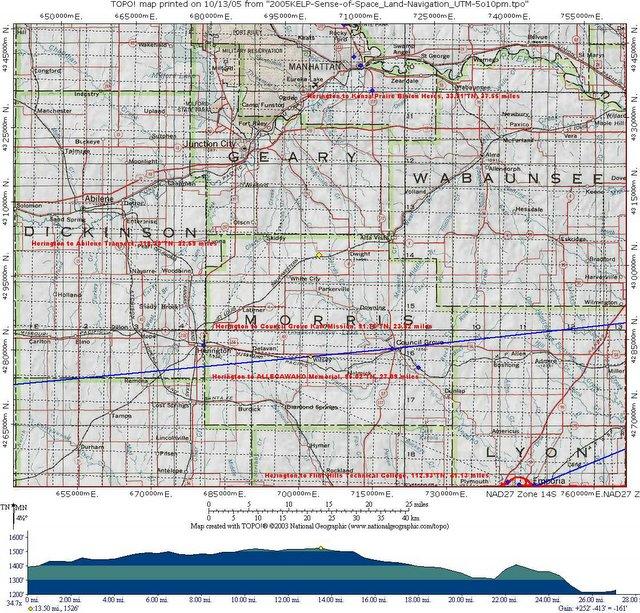
TOPO! GPS Data Format Deg
NAD27 ElevFeet
US56US77KS,
38.66736,-96.93137,1386,
HERINGTON KS-DICO
:: ELEV 1386 FT
Topeka: Konza Prairie
1 Track
10 POIs
Trek 6.3 miles into one of the last virgin tallgrass prairies in Kansas to limestone outcrops overlooking a beautiful river valley and the grazing lands of 300+ buffalo.
TO TRAILHEAD: I-70 W to exit 307.
Head N 4.9 miles on McDowell Creek Rd. R
onto Konza Prairie Ln. Trailhead .5 mile on L.
Thursday, October 06, 2005
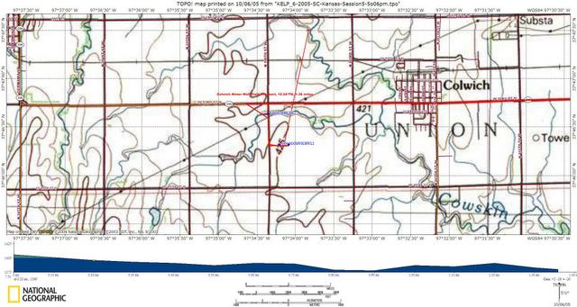
City Colwich Kansas Water Well Field Overview
Pollution Prevention Posse GPSurvey
EcoTrekUSA-i4C mapXchange
Thursday, July 14, 2005
Kaw River GPSurvey for EcoTrekUSA-i4C "Virtual Tours" mapXchange ...
CQuest: Where does beach sand come from? ...
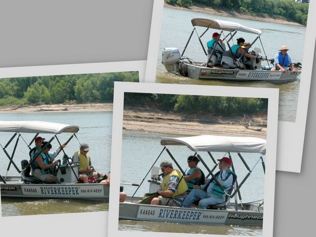
Learn about Kaw Riverkeeper "water quality" monitoring
& natural watershed changes ... over time (geomorphology)
Geomorphology, scientific study of landforms and landscapes. The term usually applies to the origins and dynamic morphology (changing structure and form) of the earth's land surfaces, but it can also include the morphology of the seafloor and the analysis of extraterrestrial terrains.
@ http://encarta.msn.com/encnet/refpages/search.aspx?q=geomorphology

