Saturday, November 26, 2005
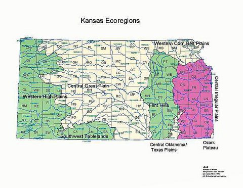
Konza Prairie & Kansas Flint Hills:
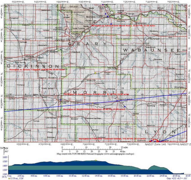
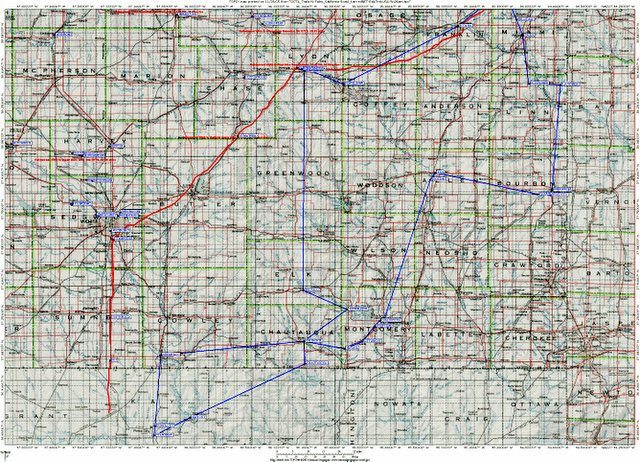
I-70 Biogeography ... (UTM-Grid)
 USGS Biogeography
Earth Sciences
Ocean River Sea Keeping Maps
TopoZone This site provides access to topographical maps of the United States "for professional and recreational map users."
Maps are searchable by place name and type of location (such as airports, beaches, and parks), Universal Transverse Mercator (UTM) coordinates, or latitude
and longitude.
The use of additional features
on the site requires a fee.
@ http://www.topozone.com
Topics: Discover New Trails at LII,
Geography, Geology, Outdoor Recreation
Last updated Sep 24, 2004
On Fire: Photographs by Larry Schwarm
A gallery of high-quality photographs of the prairie fires
that "sweep across the Flint Hills of Kansas each spring."
From the Rare Book, Manuscript,
and Special Collections Library (RBMSCL) at Duke University.
@ http://www.lib.duke.edu/exhibits/larryschwarm/
Topics: Libraries by Type, Photograph Collections,
Photograph Collections: Regional: United States, Technology
Last updated Nov 19, 2003

Labels: agritourism, distributed learning, eco-challenge, geotourism, social geocoding, social responsibility, watershed
United States -- Maps, Topographic
Prairie Passage in Kansas via Flint Hills
 Color Landform Atlas
of the United States
(view record) -->
"Each state link brings up a menu of links to maps and other online information about the state.
There are two main types of links on each state page: maps and images local to this site, and links to external Web sites."
A variety of maps are available for each state, including relief maps, topographic maps optimized to show landforms, satellite images, and maps down to county levels (except for Alaska and Hawaii).
@ http://fermi.jhuapl.edu/states/states.html
Topics: Discover New Trails at LII, Geography,
Geology, Outdoor Recreation
--> -->Last updated Aug 10, 2005
Microsoft TerraServer --> Aerial photographs and topological maps covering the United States from the United States Geological Survey (USGS). Searchable by clicking on a map, entering a placename, or selecting a site on the Famous Places page.
@ http://terraserver-usa.com/
Topics: Discover New Trails at LII, Geography,
Geology, Outdoor Recreation, Photograph Collections
--> -->Last updated Jun 5, 2003
A Tapestry of Time and Terrain:
The Union of Two Maps - Geology and Topography
--> Information about the topography and geology of the continental United States. A digital map contains the description for each geologic feature with information for the eras in which it was formed.
"Rock of Ages" is a timeline of each geologic era
linked to the regions of the map.
"Boundaries" shows two more maps: one with geomorphic,
or physiographic, regions; the other with state boundaries.
From the U.S. Geological Survey (USGS).
@ http://tapestry.usgs.gov/default.html
Topics: Discover New Trails at LII, Geography,
Geology, Outdoor Recreation
--> -->Last updated Aug 23, 2005
"Adopt-A-Habitat" Eco-Challenge ::
Know Your Watershed Impact Zones (WIZ)
Exercise Future Thought Leadership:
Advance Adult Lifelong Learning
(ALL-WinWin)
Through Environmental Literacy ...
Experience Flint Hills (OWLS)
... Prairie Passages in SE-Kansas
Advance
 Adult Lifelong Learning
 (ALL-WinWin)
Through Environmental Literacy ...
Experience Flint Hills (OWLS)
... Prairie Passages in SE-Kansas
Labels: agritourism, distributed learning, eco-challenge, geotourism, social geocoding, social responsibility, watershed
Friday, November 25, 2005
Environmental Literacy CD-ROM
 EETAP University of Wisconsin ::
Stevens Point
College of Natural Resources
Stevens Point, WI 54481
P 715.346.4958 ::: F 715.346.4385
Advancing Education through
Environmental Literacy' is a publication developed by the Association for Supervision
and Curriculum Development (ASCD) in collaboration with EETAP.
The publication focuses
on how education and the environment can be linked to advance student learning.
Included are descriptions of schools successfully implementing environmental education programs and summaries of research documenting how schools have raised test scores of their students by using the environment to help teach content in subject areas such as social studies, science, reading, and math.
Thursday, November 24, 2005
Flint Hills NWR Prairie Passages
Kanza Eco-History "Trails & Tales"
USFWS :: Kansas
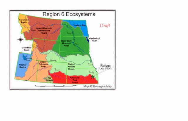
Habitat Refuge Planning
Mountain-Prairie Region Comprehensive Conservation Plans
What changed between issuing
this DRAFT version & the FINAL version?
Labels: agritourism, distributed learning, eco-challenge, geotourism, social geocoding, social responsibility, watershed
Kaw Valley Port of Shawnee
JoCo-SMP Prairie Passages
 Let's nominate inspired
"Prairie Passages" (K-12)
Educators as 2000-2005
Kan-ed / MARC
Digital Campfire
"Hometown Heroes" ...
We need to persistently recognize
& celebrate innovative regional
sustainers of Tom Peters'
(mid-June 2005)
Kan-ed Conference
Keynote RANT ...
![]()
![]()
