Wednesday, January 04, 2006
River Orienteering / Community Stewardship (RO/CS)

Adopt-A-Habitat ::
Know Your Watershed Impact Zones (WIZ)
-OR- Wilderness Inquiry Zones (geoWIZard)
Adapt "Pathfinder Passports" perspectives
@ http://en.wikipedia.org/wiki/Thinklets

Labels: agritourism, distributed learning, eco-challenge, geotourism, social geocoding, social responsibility, watershed
Tuesday, January 03, 2006
Kansas Water Plan (KWP)
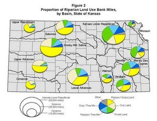
Riparian Land-Use Survey

By 2010, maintain, enhance, or restore priority wetlands and riparian areas
INTRODUCTION
In the FY 2003 Kansas Water Plan (KWP), the Kansas Water Authority approved objectives for the year 2010.
These objectives were developed to define targets to quantify achievements as part of the implementation of the KWP. The above objective is included in the Wetland and Riparian Sections of the FY 2004 Kansas Water Plan.

Labels: agritourism, distributed learning, eco-challenge, geotourism, social geocoding, social responsibility, watershed
