Thursday, July 14, 2005
Know Your Watershed Impact Zones (WIZ) "Eco-Challenge" (5714am)

Kansas-Lower Republican (KLR) Basin Advisory Committee
prototype "GeoVenturing-LNT" mapXchange Routes ...
TOPO! GPS Data Format Deg NAD83 ElevFeet
TOPO! GPS Route,KAW-LROUTES
CONCORDIA,39.57084,-97.66254,1369,CONCORDIA KS-XXCO :: ELEV 1369FT
TWINMOUND1,39.50890,-97.51142,1521,TWIN MOUNDS :: ELEV 1521FT
TOBYNEHILL,39.33167,-97.27780,1420,TOBYNE HILL :: ELEV 1420FT
POTATOHILL,39.30444,-97.29475,1450,POTATO HILL :: ELEV 1450FT TABLEMOUND,39.31222,-97.27724,1500,TABLE MOUNDS :: ELEV 1500FT TWINMOUND2,39.33278,-97.19836,1380,TWIN MOUNDS :: ELEV 1380FT RILEY,39.29889,-96.83085,1300,RILEY KS-XXCO :: ELEV 1300FT OUTLETVIEW,39.25347,-96.60547,1246,
KSUCOOPEXT,39.19418,-96.58188,1063,
MHPUBLIBKS,39.17843,-96.56570,1029,
KONZAP1997,39.13252,-96.53906,1374,
OGDEN,39.11111,-96.70612,1048,OGDEN KS-XXCO :: ELEV 1048FT JUNCTIONKS,39.02861,-96.83140,1107,JUNCTION CITY KS-XXCO :: ELEV 1107FT
CHAPMAN,38.97222,-97.02251,1113,CHAPMAN KS-XXCO :: ELEV 1113FT
ABILENE,38.91722,-97.21391,1153,ABILENE KS-XXCO :: ELEV 1153FT
SANTAFESUB,38.83914,-97.60881,1239,
LINDSBORG,38.57362,-97.67449,1332,
MCPHERSON,38.37084,-97.66421,1504,KS MCPHERSON
HERINGTON,38.67112,-96.94252,1350,HERINGTON KS-XXCO :: ELEV 1350FT
COUNCILGRV,38.68057,-96.50445,1254,KS COUNCIL GROVE WILDLIFE AREA
ALLEGAWAHO,38.62743,-96.43129,1223,
Labels: “Blog Action Day”, agritourism, distributed learning, eco-challenge, eco-history, geotourism, social responsibility, watershed
Kaw River GPSurvey for EcoTrekUSA-i4C "Virtual Tours" mapXchange ...
CQuest: Where does beach sand come from? ...
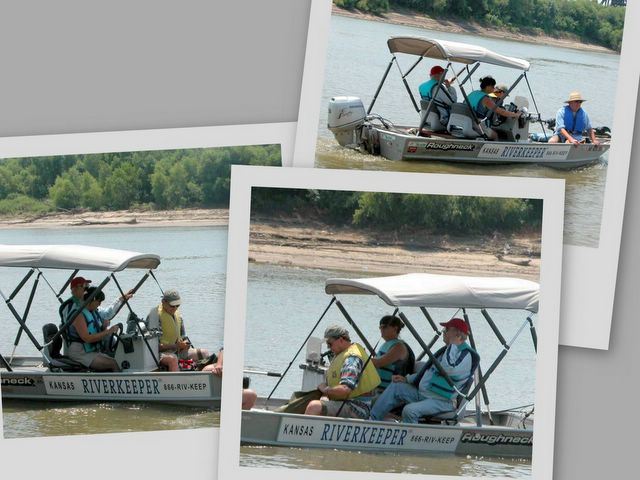
Learn about Kaw Riverkeeper "water quality" monitoring
& natural watershed changes ... over time (geomorphology)
Geomorphology, scientific study of landforms and landscapes. The term usually applies to the origins and dynamic morphology (changing structure and form) of the earth's land surfaces, but it can also include the morphology of the seafloor and the analysis of extraterrestrial terrains.
@ http://encarta.msn.com/encnet/refpages/search.aspx?q=geomorphologyEcoTrekUSA-i4C mapXchange (5714am)

KAWS "Flyway" CQuest :: What's the Kaw Valley's geomorpholgy
for Johnson County's Parks & Recreation Mill Creek Streamway?
UTM 15 338558E 4320384N (WGS84/NAD83)
... USGS Edwardsville Quad TopoZone Maps!
Monday, July 11, 2005
Scientific American "Eco-Challenge" (5711pm)
The July-2005 issue asks: "Can We Bury GLOBAL WARMING?" (pp.49-55)
An Eco-Challenge thinkLet for this topic requires crafting
"Actionable Distilled Insights" (ADI) using MentorshipART ...
Click-To-Pause:
An Eco-Challenge thinkLet for this topic requires crafting
"Actionable Distilled Insights" (ADI) using MentorshipART ...
A whole new way of viewing the WebTM
CQuest-Keywords:
"Co2Captureproject.org" Ecology Fuels Future Risk Assessment Tools
CQuest-Keywords:
"Co2Captureproject.org" Ecology Fuels Future Risk Assessment Tools
Click-To-Pause:
Digital Jayhawker "FivEZine"
Benchmarks (5711pm)
Optional :: List o’ Links
A collection of business blogs we read ...
... notes on CHANGE management dance lessons for the elephant...
tools for management and change managers
--------------------------------------------------------------------------
For "Prairie Passage in Kansas" LEARN & SHARE Tales ...
Wikipedia helped personal publishing "blaze" new digital media trails!
w:Wikimedia Foundation
From Wikinews, the free news source that you can write!
(Redirected from Wikimedia Foundation) w:Wikimedia Foundation
Contents:
1 Foundation goals
2 Foundation history and growth
3 Recent project history
4 Board of Trustees
4.1 2004-2005
5 External links
Access Encarta articles for free (Blog:5408)
Focus on ALL-WinWin :: Digital Library Resources
useful for "Kan-ed Integrated Studies Support" (KISS)
& Knowledge Management Social Engineering (KM/SE) ....
April 08 :: Access Encarta articles for free
So we got Slashdotted today, which is always fun. It's fascinating to read through the comments and see such a diverse range of responses to our humble little article editor.
There was one thing that came up in those comments that I thought I'd make a point about. Lots of people took issue with the fact that some of our articles aren't available for free on the Web.
But did you know that you can read and edit all of our articles
when you search for them through MSN Search?
http://search.msn.com/encarta/results.aspx?FORM=ENHP&q=
Yup, both our standard articles and our Premium articles are there.
Enjoy!
Aaron [aaronp_ms]
You can simply change the URL and insert the Article ID
to get full access to Encarta.
It's already described in this wikinews article: http://en.wikinews.org/wiki/MSN_Encarta_introduces_wiki-like_enhancements
Know Your Watershed Impact Zones (WIZ)
"Eco-Challenge" (5711pm)
The Eco-Challenge is a 10-day, 600-km (370-mi) event, which was first held in Utah. Like the Raid, the Eco-Challenge features five-member teams and has several stages.
Typical activities include mountain biking, sea kayaking, long-distance hiking, and skiing.
Before each year’s race, Eco-Challenge athletes participate in an environmental service project, to illustrate the power of teamwork and to promote outdoor activities that have a minimal effect on the environment.
Answer: Eco-Challenge:
The Eco-Challenge adventure race was first organized in 1995 by Mark Burnett,
a member of the first American team to compete in the Raid Gauloises.
...Learn more about Eco-Challenge Related Media Related Articles Encarta Answers
Labels: agritourism, distributed learning, eco-challenge, eco-history, geotourism, outdoor recreation, social responsibility, watershed
Sunday, July 10, 2005

Visualize Mid-America Regional Council (MARC) Greenways providing a framework for NE-Kansas Adult Lifelong Learning (ALL-WinWin) Eco-Challenge courses that encourage sustainable wellbeing ...
EcoTrekUSA-i4C mapXchange
Displays multi-disciplinary critical success factors for both Community Emergency Preparedness Teams (CEPT) and Natural Resources Crisis Management Presponse (NR-CMP)
EcoTrekUSA-i4C mapXchange
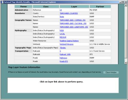
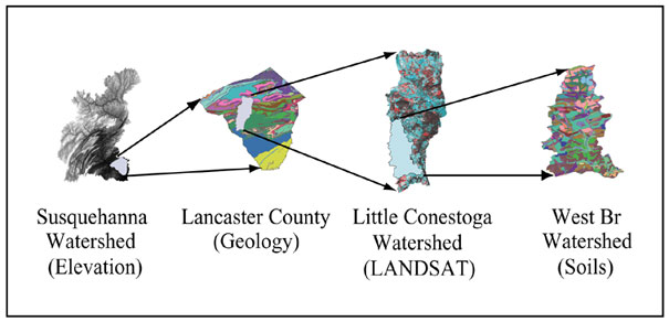
USGS National Map (Envio-Atlas Themes) for Know Your Watershed Impact Zones (geoWIZard) supporting GeoVenturing-LNT (Leave NO Trace) "Eco-Challenge"
EcoTrekUSA-i4C mapXchange
K-7 Corridor "Virtual Tour"

K-7 Corridor "Virtual Tour" from Leavenworth
to Tiblow Ferry at Bonner Springs Crossing
near the Kaw Valley's Port of Shawnee ...
EcoTrekUSA-i4C mapXchange
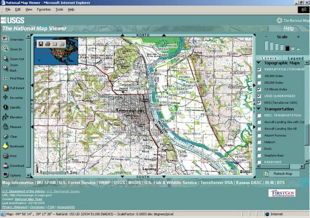
Discover NE-Kansas (K-7 Corridor) "Stranger Creek Watershed" Eco-History along the "Prairie Passage in Kansas" Wildlands Scenic Byways ... USGS National Map Viewer
EcoTrekUSA-i4C mapXchange

NGS MapMachine Topo Overview by ZIPcode
EcoTrekUSA-i4C mapXchange
![]()
![]()
