Thursday, October 13, 2005
Great Plains Geotourism GPSurvey
Watershed Orientation Kit (WOK)
TOPO! GPS Data Format Deg
NAD27 ElevFeet
US56US77KS,
38.66736,-96.93137,1386,
HERINGTON KS-DICO
:: ELEV 1386 FT

Topeka: Konza Prairie
1 Track
10 POIs
Trek 6.3 miles into one of the last virgin tallgrass prairies in Kansas to limestone outcrops overlooking a beautiful river valley and the grazing lands of 300+ buffalo.
TO TRAILHEAD: I-70 W to exit 307.
Head N 4.9 miles on McDowell Creek Rd. R
onto Konza Prairie Ln. Trailhead .5 mile on L.
Comments:
<< Home
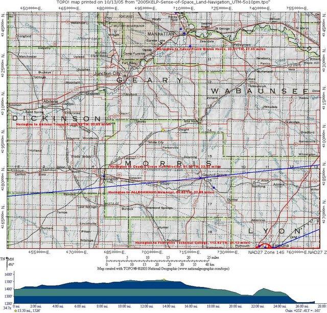
A:: Herington to Abilene Transect, 318.20°TN, 22.69 miles
B:: Herington to Council Grove Kaw Mission, 91.76°TN, 23.82 miles
C:: Herington to ALLEGAWAHO Memorial, 95.02°TN, 27.09 miles
D:: Herington to Konza Prairie Bison Herds, 33.91°TN, 37.55 miles
E:: Herington to Flint Hills Technical College, 112.93°TN, 41.13 miles
TOPO! GPS Data Format UTM NAD27 ElevFeet
US56US77KS,14S,679975,4281687,1386,
HERINGTON KS-DICO :: ELEV 1386 FT
Post a Comment
B:: Herington to Council Grove Kaw Mission, 91.76°TN, 23.82 miles
C:: Herington to ALLEGAWAHO Memorial, 95.02°TN, 27.09 miles
D:: Herington to Konza Prairie Bison Herds, 33.91°TN, 37.55 miles
E:: Herington to Flint Hills Technical College, 112.93°TN, 41.13 miles
TOPO! GPS Data Format UTM NAD27 ElevFeet
US56US77KS,14S,679975,4281687,1386,
HERINGTON KS-DICO :: ELEV 1386 FT

<< Home
![]()
![]()
