Saturday, October 08, 2005
The Kansas Geological Survey, operated by The University of Kansas in connection with its research and service program, is to conduct geological studies and research and to collect, correlate, preserve, and disseminate information leading to a better understanding of the geology of Kansas, with special emphasis on natural resources of economic value, aquifer water quality and quantity, and geologic hazards.
EcoTrekUSA-i4C mapXchange
Industrial Minerals in Kansas - is purified and suitable
for table salt and other uses requiring purity.
A solution mine in Sedgewick County produces brine that is used as a feedstock for a chloralkali plant. The brine is electrolytically separated into caustic (sodium hydroxide) and chlorine gas, both widely used in the chemical industry. Most Kansans do not realize that much of the world's salt is used in this manner.
KGS--OFR 2003-54--High Plains Aquifer--Appendix -
Investigations Report 99-4200, 6 p. Year: 1999 Contact: Steele, G.V.
Source Water Assessment Program (SWAP)
Contact: Eric Strom, Texas District Office Water ... http://www.kgs.ku.edu/...cations/2003/OFR03_54/appendix.html
High Plains Atlas-Glossary - ("first in time, first in right").
Common for allocating water rights in the western United States.
PUBLIC SUPPLY-Water used for drinking and other purposes http://www.kgs.ku.edu/HighPlains/atlas/glossary.htm

KGS--Kansas River Corridor--Economic Resources - metropolitan Kansas City area
while numerous pit dredges along the Arkansas River supply sand
for the Wichita area and much of southwestern Kansas.
http://www.kgs.ku.edu/Publications/KR/kr_econ.html
EcoTrekUSA-i4C mapXchange
Friday, October 07, 2005
Prairie Passage :: Critical Infrastructure Advisory Program (CIAP)
Pine to Prairie (P2P) Geographical Information Systems (GIS)
Eco-Futures Forum for "Crisis Management Presponse" (CMP)
EcoTrekUSA-i4C mapXchange
Lewis and Clark : Mapping on the Trail
Lewis and Clark and their Corps of Discovery
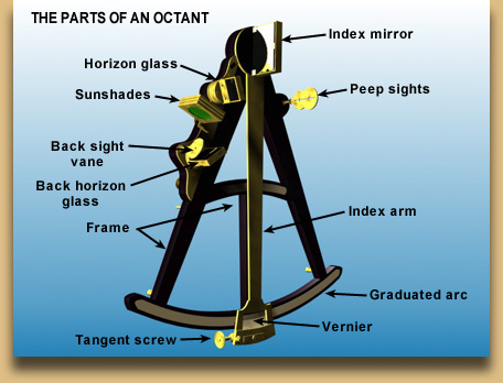
... the angle of the moon and a star with an instrument called an octant. ... http://www.edgate.com/about.php - Cached - Similar pages
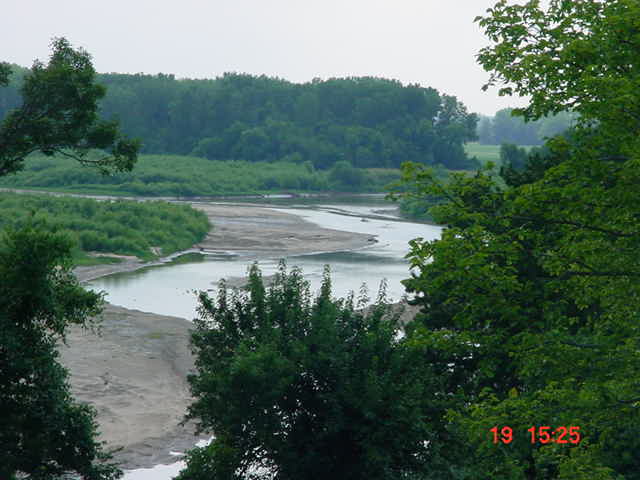
Cowskin Creek Crossing
Serendipity Happens
Re*Visioning Great Plains Eco-History "Trails & Tales"
with MentorshipART of Peace Protocols (MoPP) ...
EcoTrekUSA-i4C mapXchange
KELP6-2005_SWAP-GPSurvey_6-Oct-2005 (41 images)
(Sedgwick County) Cowskin Creek Crossing Serendipty Happens
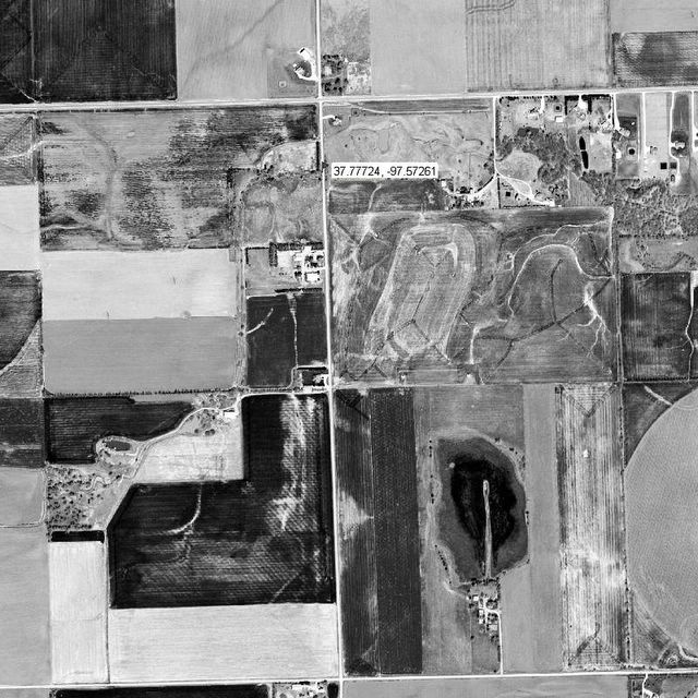
Cowskin Creek Subwatershed Orthoview :: N37.77724 /W097.57262
EcoTrekUSA-i4C mapXchange
Thursday, October 06, 2005
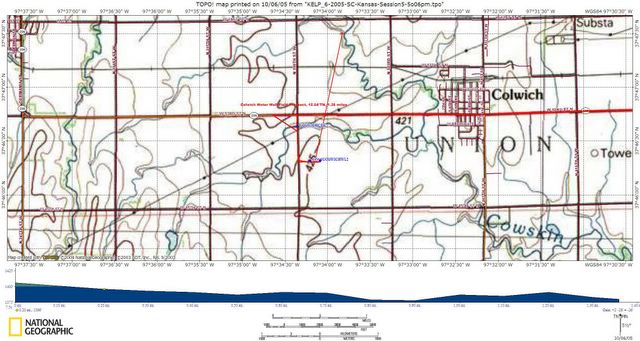
City Colwich Kansas Water Well Field Overview
Pollution Prevention Posse GPSurvey
EcoTrekUSA-i4C mapXchange
SC-Kansas KELP Class 6:2005 Session-5
:: Know Your Watershed Impact Zones (WIZ)
... Aquifer Storage & Recovery (ASR) Pilot Program Field Trip
EcoTrekUSA-i4C mapXchange
Prairie Passage in Kansas "FoodScapes"

Environmental Damage Visible From Space
Discovery Commander Eileen Collins said damage to the Earth's environment
is visible from the Discovery Space Shuttle
in a conversation with Japanese officials in Tokyo.
A CNN news story
"Sometimes you can see how there is erosion, and you can see how there is deforestation.
It's very widespread in some parts of the world," Collins said in a conversation from space
with Japanese officials in Tokyo, including Prime Minister Junichiro Koizumi.
"We would like to see, from the astronauts' point of view,
people take good care of the Earth and replace the resources that have been used,"
said Collins, who was standing with Japanese astronaut Soichi Noguchi
in front of a Japanese flag and holding a colorful fan.
Posted on August 6, 2005
EcoTrekUSA-i4C mapXchange
NE-Kansas Streamway ... "Waters to the Sea"
Stranger Creek sedement pollution seen as sandbars ...
EcoTrekUSA-i4C mapXchange
Kansas City Star 10/04/2005 Damage heavy from northeast Kansas
...Posted on Tue, Oct. 04, 2005
... Stranger Creek flooding has historically caused damage
in Easton, but the community thought it had turned a corner www.kansascity.com/mld/kansascity/news/12810539.htm
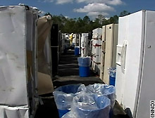
Gulf Coast USA storm clean-up crews must remove Freon
and other compents before they can recycle ruined refrigerators.
EcoTrekUSA-i4C mapXchange
(CNN) -- Tons of household chemicals that were once stored safely in garages, bathrooms and kitchen cabinets along the Gulf Coast pose a potential environmental threat after being scattered by Hurricane Katrina and its twin Rita.
Tuesday, October 04, 2005
Re*Visioning geoWIZard
Kansas Prairie Passages

Cultivating Rural Foodscapes ...
& Conserving Urban Landscapes
Discover Natural Eco-History "Trails & Tales"
via "Community Tool Box" connections ...
Our Mission:
Promoting community health and development
by connecting people, ideas and resources ...
EcoTrekUSA-i4C mapXchange
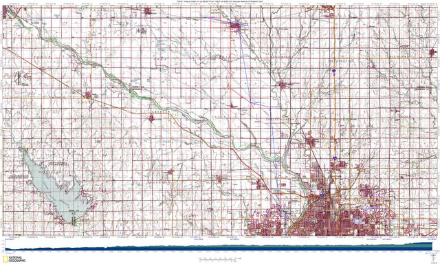
Stranger Creek Watershed DEM Topo Map
Crafted by Member of KELP Class 6:2005
Monday, October 03, 2005
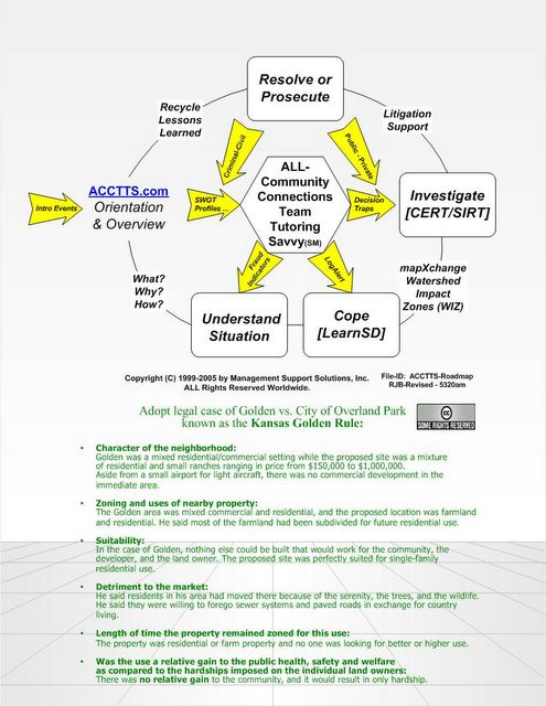
Kansas Golden Ruling ...
Prudent Person Principles
Prairie Passage "Geotourism" :: Prep-Steps
for Embracing a "Sustainable Sense of Place"
EcoTrekUSA-i4C mapXchange
Great Plains Region "Eco-History Tales & Trails"
Re*Visioning Youth Leadership Learning Legends
EcoTrekUSA-i4C mapXchange
![]()
![]()
