Tuesday, April 02, 2013
Prairie Passage EarthSea-Keeper
Sunday, February 24, 2013
Real You Decision Doorways (Draft)
Decision-Making Episodes for the Study of History and the Humanities
@ http://www.openbdb.com/e/1569760187.html
1995 Doorways to Decision Making:
A Handbook for Teaching Decision Making Strategies
@ http;//www.openbdb.com/e/1882664213.html
2002 Freeing Creative Effectiveness - Doorways Into the Upper Mind
@ http://www.openbdb.com/e/0918538041.html
There are so many new ideas about thinking, feeling, perception and intuition
in this one book that it really does jog you out of your mental rut. Try it.


Labels: action, experience, failure, focus, GlobalBrain, intentions, leadership, MindMap, results, SmartMeme, success
Saturday, January 26, 2013
FIFTH Freedom Watershed Restoration And Protection Strategies (WRAPS)

Labels: FFNHA, PlanetU, SFTA, WRAPS
Saturday, August 25, 2012
EarthSea-Keeping Guide

To understand history, F1RST understand rivers.
Example: http://mywebspiration.com/view/155897a33c7e
Sigma Nu (GDSS) Perspectives [Established 1884]
(The world of strife shut out. The world of love shut in.)
Where GDSS = Group Decision Support Systems
Seeking viable alternative futures for mutually-assured destruction (JCS-SIOP) nuclear weapons targeting.
Timeline - OK-FIRST
(Natural disaster avoidance & inter-regional mutual aide model)
* 1999: Program Manager Dale Morris is honored for his work with public safety officials.
* 2000: Oklahoma Department of Public Safety funds OK-FIRST on a recurring, annual basis.
* 2001: OK-FIRST was recognized as among five most innovative government programs
2001-2002: Collaborated with Jerry Vice who chaired SHRM Puget Sound's Organizational Development SIG to guide the Cascadia Region Earthquake Workgroup (CREW). Our UNODIR "social responsibility pathfinders" mission was reinforcing Personal Emergency Preparedness (PEP) practices that Dr. Dennis Miletti's with National Hazards Center (NHC) advocates.
We engaged Knowledge Factor's Co-Founder & Chief Learning Officer as our mind-shifting liaison. Minnesota-Wisconsin FBI InfraGard Alliance Chapters collaborated with the Minnesota Federal Executive Board (MnFEB) to conduct realistic mass-casualty incident simulations.
Aug-2007: This "Presponse Systems Thinking" framework resulted in effectively containing both scope and duration of Metro-MN's I-35W bridge collapse near the University of MN main campus.
See: http://infragardmnmembers.ning.com/profile/BobRJBurkhart
Tuesday, December 27, 2011
Mount Oread OCTA-Trails & Tales
http://www

Labels: eco-challenge, eco-history, KU GIS Day, OCTA-Trails Marker, Planet U, watershed
Tuesday, September 06, 2011
MSHS Fur Trading Post by rjburkhart at Garmin Connect
The Rivers, Trails, and Conservation Assistance Program
is the community assistance arm of the National Park Service.
RTCA supports community-led
natural resource conservation and outdoor recreation projects.
RTCA staff provide technical assistance to communities
so they can conserve rivers, preserve open space, and develop trails and greenways.
Labels: agritourism, eco-history, MentorshipART, Planet U, social responsibility, watershed
Thursday, June 30, 2011
GeoVenturing RO/CS (River Orienteering / Community Stewardship) @ http://bit.ly/khOM0i
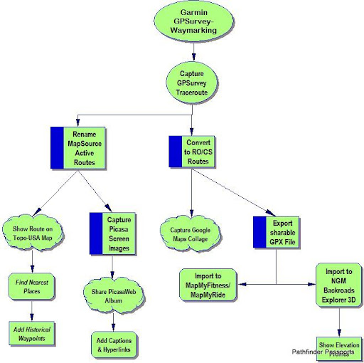
Garmin GPSurvey-Waymarking:
Capture GPSurvey Traceroute
Rename MapSource Active Routes
Show Route on Topo-USA Map
Find Nearest Places
Add Historical Waypoints
Capture Picasa Screen Images
Share PicasaWeb Album
Add Captions & Hyperlinks
Convert to RO/CS Routes:
Export sharable GPX File
Import to MapMyFitness/MapMyRide
Import to NGM Backroads Explorer 3D
Show Elevation Profiles
Capture Google Maps Collage
![]()
![]()
