Tuesday, January 31, 2006
Taum Salk Mountain Reservoir Outwash
December 14, 2005
Reservoir Break Videos
of Southeast Missouri Ozarks
Watershed Impact Zones
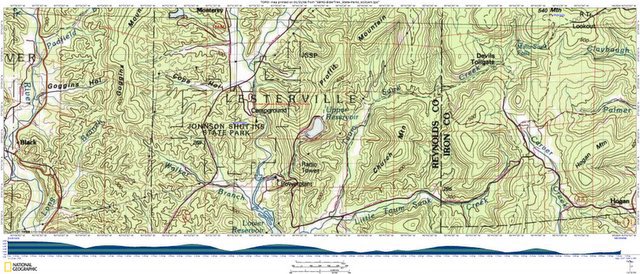
Taum Saulk to Johnson Shut-Ins State Park, 251.22°TN, 7.12 miles
REYNOLDS Co., MO:
THE NWS HAS ISSUED A *FLASH FLOOD WARNING* FOR EASTERN REYNOLDS COUNTY MO.
UPPER RESERVOIR AT TAUM SAUK POWER PLANT FAILED. FLOODING ON THE BLACK RIVER IN LESTERVILLE & MORE FLOODING LIKELY TO OCCUR DOWNSTREAM.
IT'S RPT'D THE LOWER RESERVOIR HAS BEEN OVER-TOPPED BUT IS STILL HOLDING ATT. [STL810/819/899] [STLFN]. 9:08a.m.

Labels: agritourism, distributed learning, eco-challenge, geotourism, social geocoding, social responsibility, watershed
Comments:
<< Home
Lesterville Public Meeting Update on Taum Sauk Reservoir/ Johnson's Shut-Ins
Jan. 12, 2006
Lesterville High School Gymnasium at Highway 21 and Elm
7 p.m.
Purpose-To discuss work that has occurred since the Dec. 14 breech of Taum Sauk Reservoir.
Jan. 12, 2006
Lesterville High School Gymnasium at Highway 21 and Elm
7 p.m.
Purpose-To discuss work that has occurred since the Dec. 14 breech of Taum Sauk Reservoir.

Kiluea Crater Keyword Search for USGS remote sensing resources:
usgs.gov kilauea edm "remote sensing" public safety gps survey
usgs.gov kilauea edm "remote sensing" public safety gps survey
USGS EDM-GPS Technology Integrator:
Jennifer N. Adleman
Title: Geologist
Address: 4200 University Dr.
Anchorage, AK 99508-4626
Phone: (907) 786-7019
Fax: (907) 786-7425
Jennifer N. Adleman
Title: Geologist
Address: 4200 University Dr.
Anchorage, AK 99508-4626
Phone: (907) 786-7019
Fax: (907) 786-7425
Also see:
Landslide Hazards Program - The primary objective of the National Landslide Hazards Program (LHP) is to reduce long-term losses from these hazards by improving our understanding of the causes of ground failure and suggesting mitigation strategies.
via
http://earthquake.usgs.gov/resources/other.php
Post a Comment
Landslide Hazards Program - The primary objective of the National Landslide Hazards Program (LHP) is to reduce long-term losses from these hazards by improving our understanding of the causes of ground failure and suggesting mitigation strategies.
via
http://earthquake.usgs.gov/resources/other.php
<< Home
![]()
![]()
