Saturday, December 11, 2010
Wakarusa Watershed memetics researcher


| Clear Creek Watershed Impact Zones |
Labels: distributed learning, eco-challenge, eco-history, geotourism, national heritage trail, Planet U, social geocoding, social responsibility, watershed
Saturday, April 12, 2008
Nat Geo Mag Guardian of a Ghost World:

Unforgiving Land
The Fremont culture arose before A.D. 400 in the hardscrabble region that is now most of Utah and parts of nearby states. Despite the dry, unforgiving climate, they managed to cultivate corn, beans, and squash along waterways like Range Creek and the river from which they get their name.
-----------------
From the narrative above, I was able to find end-points for a transect between river confluences & generate an elevation profile ...
Fremont River to Range Creek Confluence, 28.63°TN, 71.16 miles
TOPO! GPS Data Format Deg NAD83 ElevFeet
FREMONTRVR,,38.40248,-110.69293,NA,FREMONT RIVER ... DIRTY DEVIL (UTAH BR_4)
RANGECREEK,39.30747,-110.05708,NA,04/12/2008,16:57:14,RANGE CREEK CONFLUENCE
Labels: distributed learning, eco-history, geotourism, social geocoding, social responsibility, watershed
Wednesday, October 24, 2007
NASA World Wind Plug-In (KMLImporter)
Most notable are support for folders and icons from disk. This means that you can now simply extract a KMZ file with a tool like WinRAR, KMLImporter will then be able to find the extracted icons when you load the extracted KML.
There have been lots of small fixes regarding styles, so just about any KML with icons should load now
A new version is available at http://www.twobeds.com/shockfire/WW-Rel/KMLImporter7.zip
Labels: distributed learning, KU GIS Day, social geocoding, watershed
Wednesday, October 03, 2007
Pueblo HARP Foundation "Curriculum Guide" (7o02xm)
 Westward Movement: Spotlight of the Month-Last updated 12/07/02
December 2002 Spotlight of the Month: The Interactive Santa Fe Trail
... the author has provided good directions and GPS points to locations and photos. ...www.over-land.com/spotlite.html - Cached - Similar pages
[PDF]
Cimarron and Comanche National Grasslands Land Management Plan
Pueblo, CO: Pike and San Isabel. National Forests & Cimarron and Comanche National Grasslands Supervisor’s. Office. 65 p. + appendices, maps. ...www.fs.fed.us/r2/psicc/projects/forest_revision/PRV_CC_Plan_15.pdf - Similar pages

[PDF]
Central Front Range Regional Planning Commission
File Format: PDF/Adobe Acrobat - View as HTML
in Colorado Springs, Pueblo, and other points along the way.
... Discovery Trail and the Heart of the Rockies Trail and connects to the Santa Fe Trail, ...www.dot.state.co.us/.../Central%20Front%20Range%202030%20RTP.pdf
[PDF]
In This Issue!
File Format: PDF/Adobe Acrobat - View as HTML
Topics include creating point. features from tabular data such as GPS output,
bringing existing. hardcopy maps into your GIS, digitizing features on screen, ...www.sha.org/documents/news/newsletter/2007Fall.pdf

[PDF]
Volunteers-In-Parks
File Format: PDF/Adobe Acrobat - View as HTML
figure of $17.55 as used by AARP, Points of Light. Foundation, and other large-scale volunteer
..... outlets, assisting with the Santa Fe Trail Encampment
...www.nps.gov/archive/volunteer/FY05annualVIPreport.pdf - Similar pages
Colorado Tourism Web Sites by VisitWebs.comgis/gps certification programs colorado giuseppe old depot restaurant colorado springs ...... pueblo colorado street map pueblo colorado tourism ...visitcoloradowebs.com/ - Cached - Similar pages
Howstuffworks "Huge alphabetical list of all articles!"
How does the Nextel Cup points system work? ...
... New Mexico Scenic Drive: Santa Fe Trail ·
New Mexico Scenic Drive: Turquoise Trail · New Mexico Scenic
...www.howstuffworks.com/big.htm - Similar pages
Labels: “Blog Action Day”, agritourism, eco-challenge, KU GIS Day, outdoor recreation, social geocoding, watershed
Friday, December 01, 2006
Claim Your Blog @ Technorati
Focus on the Economy Hawaii Island Economic Development Board
February 28, 1999
Earth and space get top priority at Big Island summer camps
By K. T. Cannon-Eger
It isn't even spring yet it's time for parents and youngsters to make plans for summer camp. Several outstanding opportunities are available on the Big Island for students.
Future Flight Hawai`i celebrates its ninth anniversary with three summer programs: residential for grades four through seven, day exploration for grades three through six and family for grades two through four.
The residential program, scheduled for July 11-16, "is an intensive, space-themed program designed to catalyze student interest in science, technology and the future as well as make them aware of careers in science and technology," said Art Kimura, program director. "During the program, participants explore space science through 20 team-oriented learning modules. Then, applying their newly acquired knowledge, they are assigned to a mission crew and explore a simulated Mars landing site at Hawai`i Volcanoes National Park."
Training will include modules on robotics, life support, geology, biospheres and communications among others. An alien rendezvous will occur toward the end of the session. Housing and meals will be at Kilauea Military Camp.
The day exploration program is set for June 21-25, at UH-Hilo and offers a sampling of training modules from the more extensive residential program. Among possible activities are biosphere construction, robotics, pneumatics, life support and geology.
The family program, scheduled for the weekend of July 16-18, at Kilauea Military Camp and Hawai`i Volcanoes National Park.
Parents and students will participate "in the intensive, educational program involving a rigorous schedule of activities, which is conducted well into the evening," Kimura said. "In addition to the activities, a major activity will be a field trip to a lava field."
Future Flight Hawai`i is part of the Hawai`i Space Grant College of the University of Hawai`i. For more information on fees and schedules, contact Kimura at:
art@kalama.doe.hawaii.edu or telephone (808) 934-7261 or write Hawai`i Space Grant College, 2525 Correa Road, Honolulu HI 96822. Registration is on a first come, first served basis.
Labels: distributed learning, geotourism, KU GIS Day, outdoor recreation, social geocoding, watershed
Sunday, November 19, 2006
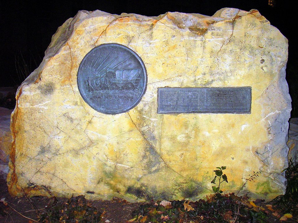
Oregon-California Trail Marker:
KU Campus Hilltop Benchmarks
According to the Princeton Review of 361 Best Colleges, KU is a "College with a Conscience" and among the top 81 schools in the country when it comes to service-learning programs and blending academics with community service.
* Fifth Annual KU GIS Day 2006 Participants :: Social Geocoding Sampler
* Real-time GPS tracking map for GISpeaker Tim Hibbard
* CIMS: Campus Incident Management Systems * Future Thought Leadership* embraces the mentorship art of anticipatory thinking? using futures techniques?. The purpose of blended visual learning? protocols is to show connections between cause and (un)intended consequences.
Labels: KU GIS Day, OCTA-Trails Marker, social geocoding, social responsibility
Sunday, April 23, 2006
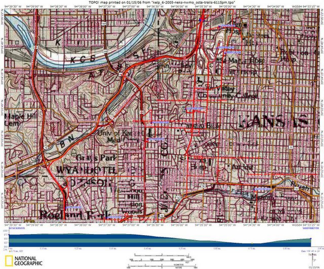
Tom Parker :: dispatches from kansas (6423pm)
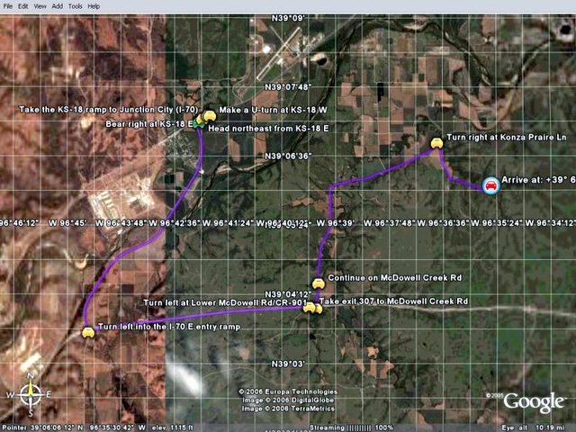
TOPO! GPS Data Format Deg NAD27 ElevFeet
TOPO! GPS Route,KONZAPRAIRIE
KONZARIVER,39.11528,-94.60917,722,KANSAS RIVER (KAW POINT)
KINGSCREEK,39.11972,-96.61472,1050,KINGS CREEK :: KVHA-STREAMLINK PATHFINDER PASSPORT
CONFLUENCE,39.10139,-96.59194,1105,KINGS CREEK BRANCHES
SBRKINGSCK,39.09107,-96.58596,1162,SOUTH BRANCH KINGS CREEK
SBRKNG1213,39.08779,-96.57721,1213,14:35:26,
SBRKNG1224,39.08437,-96.58332,1224,14:36:47,
KONZAPRAIR,39.09306,-96.55833,1372,KONZA PRAIRIE NATURAL AREA
NBRKINGSCK,39.08789,-96.55598,1403,NORTH BRANCH KINGS CREEK
Experience http://Virtual-Team-Tactics.futurethought.info
Labels: distributed learning, eco-challenge, geotourism, social geocoding, social responsibility, watershed
Sunday, April 16, 2006
AgGard Orientation :: Brownfield Network (6416pm)
Council Grove, Kansas Forum on News:
Nebraska receives EPA grant to fund watershed project ...
Monday, April 3, 2006, 2:38 PM by Lane McConnell
A grant for $810,000 from the Environmental Protection Agency was awarded to Governor Dave Heineman to help support a cooperative water quality protection ...
Visit Brownfield Network Ag-News Blog: http://learfieldcreative.typepad.com/brownfield/
EcoTrekUSA-i4C mapXchange
Labels: distributed learning, eco-challenge, geotourism, social geocoding, social responsibility, watershed
Eco-History Trails & Tales
Backcasting & Forecasting (6416pm)

These early Osage Nation trails and traces may have been used by mid-continent Native Americans. Some portion of these trails were used as fur trading routes pre-dating the Santa Fe Trail and other cutoffs ...
Edward Mosley was the second major American trader to arrive in Kansas in the late 1850s.
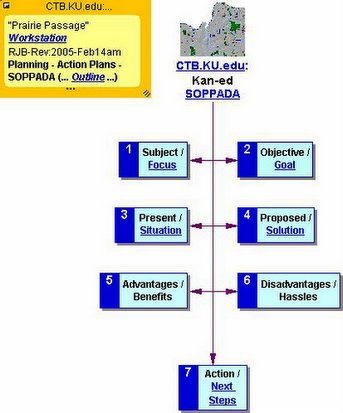
Introduction to "Praire Passage" Future Studies Topics
Indeed, no futurist would dedicate their whole life to studying change frameworks
... see those outlined by Earl Joseph of the Minnesota World Future Society Chapter. ... http://www.csudh.edu/global_options/IntroFSTopics.HTML
EcoTrekUSA-i4C mapXchange
Labels: distributed learning, eco-challenge, geotourism, social geocoding, social responsibility, watershed
Tracing the ancient paths (6416pm)

Story by TERRI BAUMGARDNER; Map by DAVE EAMES
You could pull back the concrete ribbons that we travel now,
you'd find a skeleton of paths that date to the days before Christ.
Sunday, April 16, 2006 (KansasCity.com)
TOPO! GPS Data Format Deg NAD27 ElevFeet
JAYWALKWPF,39.56202,-95.11323,770, NE-Kansas EcoTrekUSA
EcoTrekUSA-i4C mapXchange
Labels: distributed learning, eco-challenge, geotourism, social geocoding, social responsibility, watershed
Sunday, February 12, 2006
ALL-WinWin "MentorshipART of Peace" Guidelines
 Since this blog was launched during mid-June, 2005 ... it's publsher posted ten (10) "thinkLets" about this topic:
To view prior pieces of this ALL-WinWin puzzle, just click [HERE] ...
Labels: distributed learning, eco-challenge, geotourism, social geocoding, social responsibility, watershed
Saturday, February 11, 2006
Hawaiiana Heritage :: Ahupua'a Lifestyle
 Kamehameha Schools published a poster showing sustainable use of resources from the mountain (mauka) to the sea (makai) to help preserve and protect Hawaiian Island habitats.
North Hawaii District "foodscapes" along the Hilo-Hamakua Heritage Coast showcase multi-generational examples of these savvy land-use practices ...
For more information, visit http://hiedb.org to learn more about Ag-Tourism land-use mapping.
Also see EcoTrekUSA: Alakakai National Heritage Trail Planner
Na Ala Hele Contacts
Hawaii:Irv Kawashima
Na Ala Hele Trails & Access
SpecialistDepartment of Land & Natural Resources
19 East Kawili Street
Hilo, Hawaii 96720tele: 808 974-4217 email: ikawashima@dofawha.org
Labels: agritourism, distributed learning, eco-challenge, geotourism, national heritage trail, social geocoding, social responsibility, watershed
Tuesday, January 31, 2006
Taum Salk Mountain Reservoir Outwash
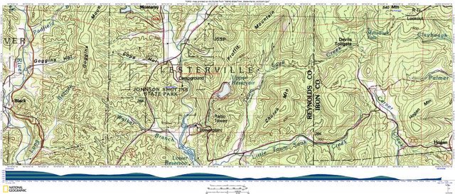
December 14, 2005
Reservoir Break Videos
of Southeast Missouri Ozarks
Watershed Impact Zones
Taum Saulk to Johnson Shut-Ins State Park, 251.22°TN, 7.12 miles
REYNOLDS Co., MO:
THE NWS HAS ISSUED A *FLASH FLOOD WARNING* FOR EASTERN REYNOLDS COUNTY MO.
UPPER RESERVOIR AT TAUM SAUK POWER PLANT FAILED. FLOODING ON THE BLACK RIVER IN LESTERVILLE & MORE FLOODING LIKELY TO OCCUR DOWNSTREAM.
IT'S RPT'D THE LOWER RESERVOIR HAS BEEN OVER-TOPPED BUT IS STILL HOLDING ATT. [STL810/819/899] [STLFN]. 9:08a.m.
Labels: agritourism, distributed learning, eco-challenge, geotourism, social geocoding, social responsibility, watershed
Sunday, January 15, 2006
KCMO Passports for Hidden Hometown Heroes
THOMAS HART BENTON HOME:
3616 Belleview. 10 a.m.-4 p.m.
Mondays-Saturdays;
noon-5 p.m. Sundays.
Admission charge. (816-931-5722)
TOPO! GPS Data Format
Deg NAD83 ElevFeet
HSTPRESLIB,39.10348,-94.42020,1019,
MODNRBENTH,39.06214,-94.59791,953, ...
[A] HS Truman Library to Thomas Benton Home, 253.56°TN, 10.00 miles
[B] MoDNR Discovery Center to Benton House, 318.79°TN, 1.93 miles
[C] KCMO Union Stn to MoDNR Benton House, 202.44°TN, 1.69 miles
[D] KUMC Parking to MnDNR Benton House, 50.35°TN, 0.87 miles
Also see Wikipedia article about: Thomas Hart Benton (painter)
@ http://en.wikipedia.org/wiki/Thomas_Hart_Benton_(painter)
Labels: agritourism, distributed learning, eco-challenge, geotourism, social geocoding, social responsibility, watershed
Wednesday, January 04, 2006
River Orienteering / Community Stewardship (RO/CS)

Adopt-A-Habitat ::
Know Your Watershed Impact Zones (WIZ)
-OR- Wilderness Inquiry Zones (geoWIZard)
Adapt "Pathfinder Passports" perspectives
@ http://en.wikipedia.org/wiki/Thinklets
Labels: agritourism, distributed learning, eco-challenge, geotourism, social geocoding, social responsibility, watershed
Tuesday, January 03, 2006
Kansas Water Plan (KWP)
Riparian Land-Use Survey

By 2010, maintain, enhance, or restore priority wetlands and riparian areas
INTRODUCTION
In the FY 2003 Kansas Water Plan (KWP), the Kansas Water Authority approved objectives for the year 2010.
These objectives were developed to define targets to quantify achievements as part of the implementation of the KWP. The above objective is included in the Wetland and Riparian Sections of the FY 2004 Kansas Water Plan.
Labels: agritourism, distributed learning, eco-challenge, geotourism, social geocoding, social responsibility, watershed
Saturday, December 31, 2005
"Eco-History Trails & Tales" thinkLets(cc)
Expereince Kaw Valley's
StreamLinks Hyperportal via
"Eco-History Trails & Tales" mapXchange(cc)
Click above to EXPLORE
a graphical table of contents:
Also see ... Apollo-13 Mission thinkLets
Re*Cycling Pacific Recovery Forces
(precision navigation)
"lessons learned" ...
Labels: agritourism, distributed learning, eco-challenge, geotourism, social geocoding, social responsibility, watershed
Monday, December 26, 2005
River Orienteering / Community Stewardship (RO/CS) ... "Eco-History Trails & Tales" ...
Something to Think About:
"Our planet is invested with two great oceans; one visible, the other invisible; one underfoot, the other overhead; one entirely envelopes it, the other covers about two thirds of its surface."
Matthew F. Maury
(Godfather of Oceanography)
From ... The Physical Geography of the Seas and Its Meteorology, 1855 ...
Matthew Fontaine Maury
7 Jan 2005 by W. R. King
Maury—Matthew Fontaine Maury—was born in 1806 in Fairfax just north of Richmond, ... in this one-time capitol, Maury was the “pathfinder of the seas,” not only a competent navy man but a hero of Commerce and the creator of Oceanography. ...
In the Physical Geometry of the Sea, which in ’55 outsold it seems even Shakespeare, (Maury) that it was Psalm 8:8, “the birds of the air, the fish of the sea, whatever passes along the paths of the seas,” that provided the spark to his intellectual fire, for at that time he realized that God, though seated in heaven, had left His mark elsewhere, too.
oceanology - wikipedia article about oceanology.
biological oceanography or marine biology marine biology is the study of animal...
Maury (January 14 1806 – February 1 1873), nicknamed "Pathfinder of the seas" ...
encyclopedia.thefreedictionary.com/Oceanology
List of environment topics - SFA Software Knowledgebase...
(Pacific manta) (devil ray) (devilfish) (manta); mantle (geology) ...
geology: See) oceanography; (marine life: See) marine biology; ...
www.sfasoft.com/kb/List_of_environment_topics
List of environment topics
my Dictionary with pronunciation, wikipedia etc ...
(marine farming: See) aquaculture;(marine geology: See)
oceanography; (marine life: See) marine biology ...
www.algebra.com/algebra/about/ history/List-of-environment-topics.wikipedia
Labels: agritourism, distributed learning, eco-challenge, geotourism, social geocoding, social responsibility, watershed
Sunday, December 25, 2005
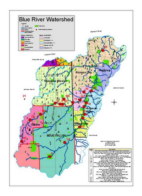
Meet Your Kansas - Lower Republican
Sub-Watershed (HUC-8) Stream Teams
We offer the award winning book
"Exploring the Kaw Valley" by Lynn Byczynski
http://www.streamlink.org/

| To visit your subwatershed, just click on this StreamLink Map or choose from the choices listed below. |
Lower
Republican
(10250017)
Upper
Kansas (10270101)
Middle
Kansas (10270102)
Delaware
(10170103)
Kansas
(10270104)
Lower
Big Blue (10270205)
Lower Little Blue (10270207)
Middle Republican (10250016)
Labels: agritourism, distributed learning, eco-challenge, geotourism, social geocoding, social responsibility, watershed
Saturday, December 17, 2005
Know Your Watershed Impact Zones:
Kansas-Nebraska geoWIZard Connections

Don't Know Much about Biogeography ...
What-IF ::
Great Plains geo-political land-use survey boundaries got BLURred
to help us protect and preserve natural topographical boundaries?
Re*Visioning ::
EcoTrekUSA-i4CQuest ...
Keywords: "Semantic Web"
"Sea Turtles" Future Mentor
Orlando Chapter STC: Education Committee
Sea Turtles vs. Human Indifference, Lauren Pell,
Deltona HS 12th Grade,
Ms. Cynthia Boor.
Weaving the Semantic Web ...
http://www.stc-orlando.org/education/
goals/report_2003-2004.asp
- Cached - Similar pages
Development
A Look Into My (Possible) Future ...
Help Save a Life! is a science-based unit that creates awareness
about marine life— specifically sea turtles. ...
http://www.teachersnetwork.org/ development/teachnet_query_all.cfm
Help Save A Life!
Mathematics,Science,Technology 4
Help Save a Life! is a science-based unit that creates awareness
about marine life—specifically sea turtles. Students first read books
and other research obtained from teacher-approved Web sites.
http://www.teachersnetwork.org/ impactii/profiles03_04/beharry.htm
Pickler Memorial Library Accessions List
C536 S69 2004, Sea turtles : a complete guide to their biology, behavior, ...
P37 2004, Explorer's guide to the Semantic Web / Thomas B. Passin. TP1180. ... http://library.truman.edu/accessions/ FY%2005%20Accessions/June-05-accessions-list.htm - Cached - Similar pages
Labels: agritourism, distributed learning, eco-challenge, geotourism, social geocoding, social responsibility, watershed
![]()
![]()
