Saturday, November 26, 2005
Konza Prairie & Kansas Flint Hills:
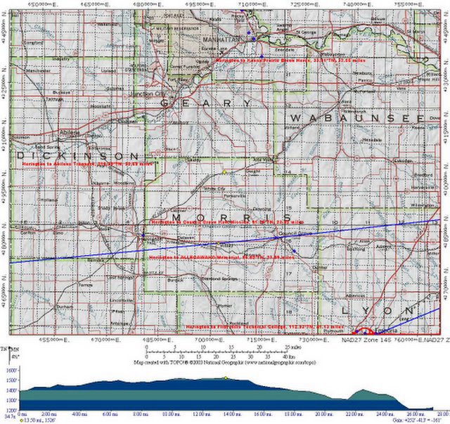
I-70 Biogeography ... (UTM-Grid)
 USGS Biogeography
Earth Sciences
Ocean River Sea Keeping Maps
TopoZone This site provides access to topographical maps of the United States "for professional and recreational map users."
Maps are searchable by place name and type of location (such as airports, beaches, and parks), Universal Transverse Mercator (UTM) coordinates, or latitude
and longitude.
The use of additional features
on the site requires a fee.
@ http://www.topozone.com
Topics: Discover New Trails at LII,
Geography, Geology, Outdoor Recreation
Last updated Sep 24, 2004
On Fire: Photographs by Larry Schwarm
A gallery of high-quality photographs of the prairie fires
that "sweep across the Flint Hills of Kansas each spring."
From the Rare Book, Manuscript,
and Special Collections Library (RBMSCL) at Duke University.
@ http://www.lib.duke.edu/exhibits/larryschwarm/
Topics: Libraries by Type, Photograph Collections,
Photograph Collections: Regional: United States, Technology
Last updated Nov 19, 2003

Labels: agritourism, distributed learning, eco-challenge, geotourism, social geocoding, social responsibility, watershed
Comments:
<< Home
The Librarian's Internet Index (LII) was an unexpected discovery when seeking more information about using UTM Grid Systems ...
Example: related:www.lii.org/sdcl%3Fquery%3DMaps%3Bsearchtype%3Dsubject%3Bview_all%3DPlease
Post a Comment
Example: related:www.lii.org/sdcl%3Fquery%3DMaps%3Bsearchtype%3Dsubject%3Bview_all%3DPlease

<< Home
![]()
![]()
