Monday, November 07, 2005
Experience California National Parks
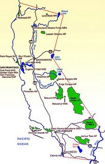 Getting to Death Valley
The park is transected from east to west by California Highway 190. On the east in Nevada, Highway 95 parallels the park from north to south with connecting highways at Scotty's Junction (State Route 267), Beatty (State Rt. 374), and Lathrop Wells (State Rt. 373).
South of the park, Interstate 15 passes through Baker, California on its way from Los Angeles to Las Vegas. State Rt. 127 travels north from Baker to Shoshone (State Rt.178) and Death Valley Junction (Highway 190).
West of the park, State Rt. 178 passes through Ridgecrest and Trona on its way north to a junction with 190. Also to the west, Highway 395 parallels the park from north to south with connections to Highway 190 at Olancha and Lone Pine.
Nearest airport: Las Vegas (120 miles).
For More Information
Write to Death Valley National Park,
P.O. Box 579, Death Valley, CA 92328-0579;
Telephone (760) 786-2331; Fax (760) 786-3283;
Web site: http://www.nps.gov/deva.

Labels: agritourism, distributed learning, eco-challenge, geotourism, social geocoding, social responsibility, watershed
Comments:
<< Home
Favorite Day Hikes
In spite of its size, the park has only a few developed trails (Telescope Peak, Wildrose Peak, Salt Creek boardwalk, Harmony Borax Works, a portion of Golden Canyon).
Still, it offers many worthwhile, less-traveled routes where it's not hard to go your own way.
Telescope and Wildrose peaks, at high elevation, are the only walks that could be considered SAFE to explore during summer months.
TOPO! GPS Data Format
Deg NAD27 ElevFeet
TELESCOPK ,36.16972,-117.08778,11049,TELESCOPE PEAK
WILDROSEPK,36.27583,-117.07806,9064,WILDROSE PEAK
-----------------------------------
Consider exploring Fall Canyon, a moderately strenuous hike (three miles each way; five miles further to reach a more challenging dry fall).
The terrain is gravel wash; there is no clearly marked trail. You'll need to have some scrambling ability to get beyond the dry fall.
To get to the "trailhead," located in the Grapevine Mountains, northwest of Furnace Creek, take the Titus Canyon turnoff off of Scotty's Castle Road.
Drive three miles on a dirt road to the Titus Canyon parking area (west end). Walk north from the behind the parking area/rest areas, then turn northeast up a large, gravel wash for 2.5 miles to the first dry fall.
The rocky footing and uphill grade are easy enough but can be tiring; the going is slower than a typical trail walk.
A challenging, non-technical climb on the south side of the wash (about 100 yards before the dry fall) will allow you to continue further and explore the narrows beyond the fall.
Bighorn sheep are present in the area. Though you may not see them, you may find evidence of their presence.
The best time to visit is October through March. Plan to get an early start to avoid the midday sun.
Post a Comment
In spite of its size, the park has only a few developed trails (Telescope Peak, Wildrose Peak, Salt Creek boardwalk, Harmony Borax Works, a portion of Golden Canyon).
Still, it offers many worthwhile, less-traveled routes where it's not hard to go your own way.
Telescope and Wildrose peaks, at high elevation, are the only walks that could be considered SAFE to explore during summer months.
TOPO! GPS Data Format
Deg NAD27 ElevFeet
TELESCOPK ,36.16972,-117.08778,11049,TELESCOPE PEAK
WILDROSEPK,36.27583,-117.07806,9064,WILDROSE PEAK
-----------------------------------
Consider exploring Fall Canyon, a moderately strenuous hike (three miles each way; five miles further to reach a more challenging dry fall).
The terrain is gravel wash; there is no clearly marked trail. You'll need to have some scrambling ability to get beyond the dry fall.
To get to the "trailhead," located in the Grapevine Mountains, northwest of Furnace Creek, take the Titus Canyon turnoff off of Scotty's Castle Road.
Drive three miles on a dirt road to the Titus Canyon parking area (west end). Walk north from the behind the parking area/rest areas, then turn northeast up a large, gravel wash for 2.5 miles to the first dry fall.
The rocky footing and uphill grade are easy enough but can be tiring; the going is slower than a typical trail walk.
A challenging, non-technical climb on the south side of the wash (about 100 yards before the dry fall) will allow you to continue further and explore the narrows beyond the fall.
Bighorn sheep are present in the area. Though you may not see them, you may find evidence of their presence.
The best time to visit is October through March. Plan to get an early start to avoid the midday sun.

<< Home
![]()
![]()
