Thursday, June 30, 2011
GeoVenturing RO/CS (River Orienteering / Community Stewardship) @ http://bit.ly/khOM0i
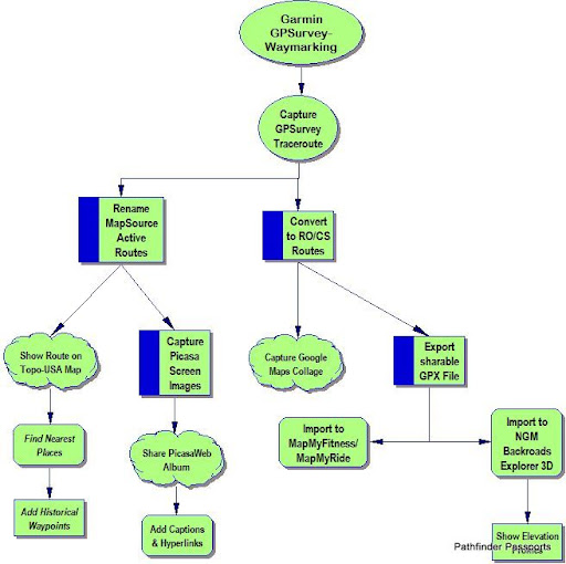
Garmin GPSurvey-Waymarking:
Capture GPSurvey Traceroute
Rename MapSource Active Routes
Show Route on Topo-USA Map
Find Nearest Places
Add Historical Waypoints
Capture Picasa Screen Images
Share PicasaWeb Album
Add Captions & Hyperlinks
Convert to RO/CS Routes:
Export sharable GPX File
Import to MapMyFitness/MapMyRide
Import to NGM Backroads Explorer 3D
Show Elevation Profiles
Capture Google Maps Collage
Comments:
<< Home

Garmin BaseCamp Software Review: QUANTITY OVER QUALITY
Pros: nice shading and detail,
nice overview
Cons: not routable, useless 3d
The Basecamp software that comes with this map is well intentioned, but the 3D is not useful at this time. The Garmin techs say that it works, but it is incredibly slow. They are right. Running on my IBM Thinkpad T43 it takes about sixty seconds to redraw the screen each time you move the map.
*** I workaround for the routable problem for road cyclists can be accomplished if you own City Navigator North America NT. To "beat" this routable problem you lay out your route using NT and then switch the underlying map to Topo USA 100k. Your route will be overlayed and then you can ask for the profile. Kind of cool. This little discovery saved me from kicking myself for an additional week or two after wasting $100 on Topo 100K USA.
This software might be useful to a hiker who wants to have a basemap loaded on their GPS that will allow them to orient themselves as they hike. Sort of, "Where am I now?," approach. I will allow you to trace your route and foresee obstacles before you get to them. It also gives a nice overview of the topography of large areas. You can pull back and look at a whole state or the whole country.
If you want routable topographical maps then purchase the 24K USA Topographical map that conforms to the region that you will be exploring.
[Ed. note: Awesome review Ken! Thanks.]
Post a Comment
Pros: nice shading and detail,
nice overview
Cons: not routable, useless 3d
The Basecamp software that comes with this map is well intentioned, but the 3D is not useful at this time. The Garmin techs say that it works, but it is incredibly slow. They are right. Running on my IBM Thinkpad T43 it takes about sixty seconds to redraw the screen each time you move the map.
*** I workaround for the routable problem for road cyclists can be accomplished if you own City Navigator North America NT. To "beat" this routable problem you lay out your route using NT and then switch the underlying map to Topo USA 100k. Your route will be overlayed and then you can ask for the profile. Kind of cool. This little discovery saved me from kicking myself for an additional week or two after wasting $100 on Topo 100K USA.
This software might be useful to a hiker who wants to have a basemap loaded on their GPS that will allow them to orient themselves as they hike. Sort of, "Where am I now?," approach. I will allow you to trace your route and foresee obstacles before you get to them. It also gives a nice overview of the topography of large areas. You can pull back and look at a whole state or the whole country.
If you want routable topographical maps then purchase the 24K USA Topographical map that conforms to the region that you will be exploring.
[Ed. note: Awesome review Ken! Thanks.]
<< Home
![]()
![]()
